skip to main |
skip to sidebar
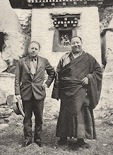
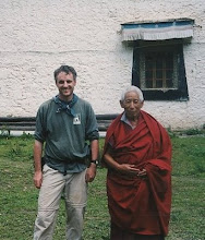
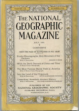
Dr Joseph Rock was an Austrian-American botanist who explored the Tibetan borderlands of Sichuan and Yunnan in the 1920s and 30s. This is about my travels to revisit the places he described in the National Geographic magazine. Any questions? contact me at beijingweek AT gmail

Kham then and now. A photoblog showing how eastern Tibet looked in the 1920s and how the same places and people look now. Based on the explorations of botanist Joseph Rock.
About this blog
Dr Joseph Rock was an Austrian-American botanist who explored the Tibetan borderlands of Sichuan and Yunnan in the 1920s and 30s. This is about my travels to revisit the places he described in the National Geographic magazine. Any questions? contact me at beijingweek AT gmail
Chapters
- 1. How it all began
- 2. Joseph Rock and China
- 3. Kunming and Dali, 1990
- 4. Muli, Land of the Yellow Lamas
- 5. The Glories of Minya Konka (Gonga Shan)
- 6. Visiting the lost mountain of Muti Konka
- 7. Yading: Konkaling, Holy Mountains of the outlaws
- 8: Seeking the Mountains of Mystery: Choni and Ragya
- 9. Through the Great River Trenches of Asia: the Mekong
- 10: From the Mekong to the Salween via the Sila Pass
- 11. The Salween from Bingzhongluo to Chawalong
- 12. The Kawakarpo Kora Pt 1: Doker La
- 13: The Kawakarpo Kora Part 2: Sho-La Pass
- Extra: Yading Kora 2016 TV documentary diary
- Extra: How to do the Kawakarpo Outer Kora
Blog Archive
-
►
2005
(554)
- January (92)
- February (106)
- March (85)
- April (61)
- May (53)
- June (36)
- July (65)
- August (1)
- October (4)
- November (49)
- December (2)
-
►
2006
(343)
- January (88)
- February (11)
- March (9)
- April (8)
- May (74)
- June (17)
- July (34)
- August (6)
- September (10)
- October (39)
- November (27)
- December (20)
-
►
2007
(103)
- January (3)
- February (6)
- April (10)
- May (8)
- June (35)
- July (5)
- August (14)
- September (9)
- October (7)
- November (1)
- December (5)
-
►
2008
(104)
- January (37)
- February (15)
- March (2)
- July (13)
- September (12)
- October (12)
- November (12)
- December (1)
-
►
2012
(61)
- January (1)
- March (10)
- April (14)
- May (10)
- June (4)
- July (3)
- August (7)
- November (2)
- December (10)
-
►
2013
(124)
- January (10)
- April (5)
- May (6)
- June (6)
- July (5)
- August (40)
- September (28)
- October (4)
- November (13)
- December (7)
-
►
2014
(92)
- January (3)
- February (2)
- March (42)
- April (1)
- July (1)
- August (2)
- September (10)
- October (9)
- November (16)
- December (6)